
 Email Alerts
 RSS
RSS
Experimental investigation of the optimal image acquisition conditions for Unmanned Aerial Vehicles (UAVs) used in dam safety inspections
-
摘要:
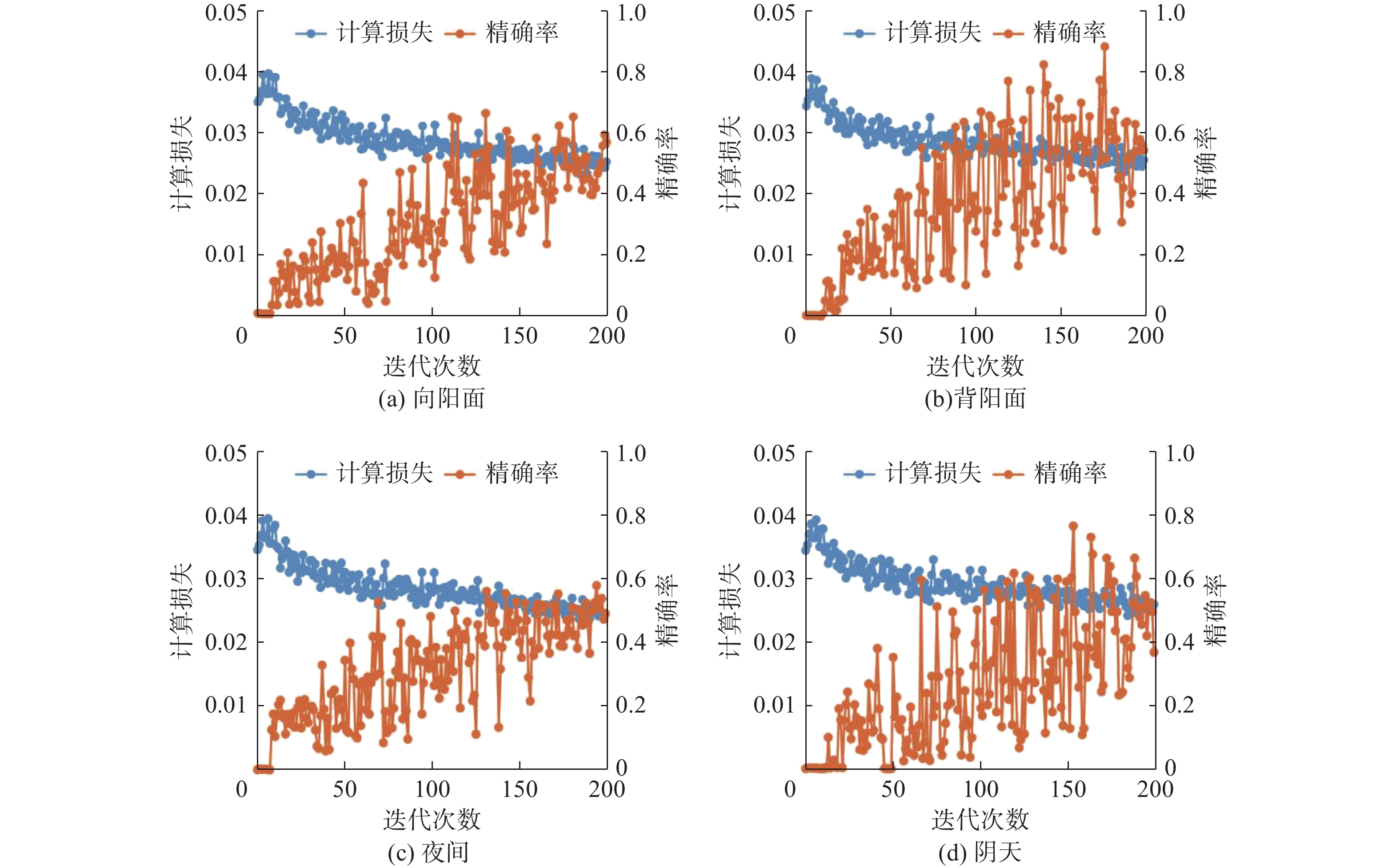
为提高大坝安全巡检无人机图像采集的有效性,针对拍摄距离、风速和光照条件三项重要影响因素,基于大疆Phantom 4 Pro无人机开展试验,分别结合图像自适应阈值二值化、无人机位移及深度学习方法对图像的信息提取效果进行评估,从而研究无人机大坝巡检最优的图形采集工况。研究结果表明,在拍摄距离为3 m、单向风速为2.5~4.0 m/s范围内、晴天背阳的光照条件下,无人机悬停能力较好,不会与被拍摄物体表面发生碰撞,且采集的图像质量最佳。优化了无人机图像采集方案,为基于无人机巡视大坝工作提供参考依据。未来可以进一步应用自动化巡检系统、传感器技术和智能飞行控制算法,实现无人机在大坝安全巡检中的全面应用。
Abstract:In order to enhance the effectiveness of Unmanned Aerial Vehicle (UAV) image acquisition for dam safety inspections, this study focuses on three crucial factors: shooting distance, wind speed, and illumination conditions. Using the DJI Phantom 4 Pro UAV as the experimental platform, a series of UAV experiments were conducted under varying shooting distances, wind speeds, and illumination conditions. The image information extraction effectiveness was evaluated through a combination of image adaptive binarization, UAV displacement analysis, and deep learning techniques. The objective was to determine the optimal conditions for acquiring high-quality images during UAV-based dam inspections. The results indicate that the UAV demonstrates excellent hovering capabilities and avoids collision with the target surface under specific conditions, including a shooting distance of 3 meters, a unidirectional wind speed ranging from 2.5 to 4.0 m/s, and favorable sunny backlit conditions. This study optimizes the image acquisition scheme for UAV inspections and provides valuable insights for dam safety inspections utilizing UAV technology. Furthermore, future advancements in automatic inspection systems, sensor technology, and intelligent flight control algorithms can further enhance the comprehensive application of UAVs in dam safety inspections.
-
Keywords:
- dam safety inspection /
- UAV /
- shooting spacing /
- wind speed /
- lighting
-
-
![]()
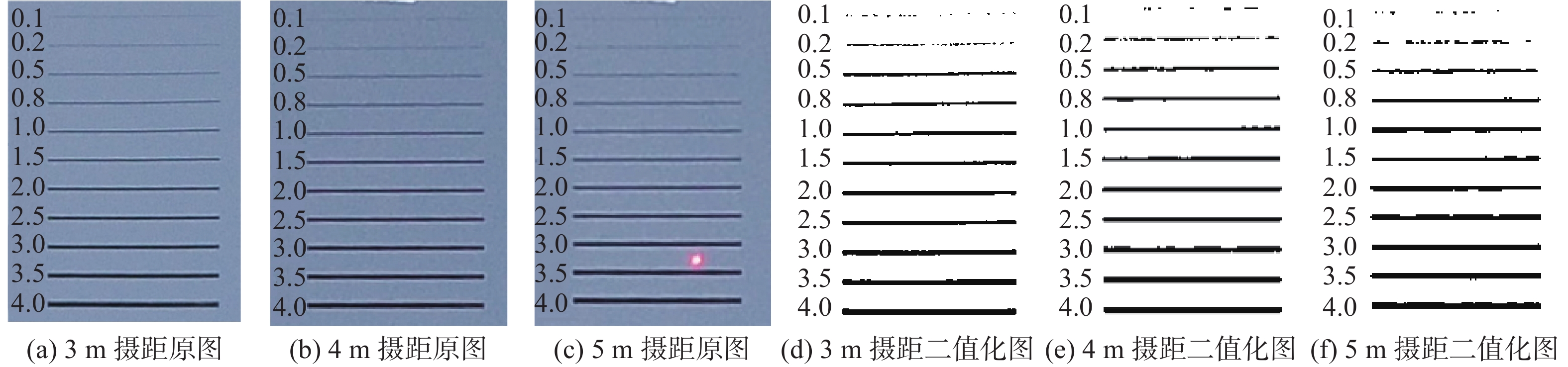
图 3 3种摄距下原图和二值化模拟裂缝图像对比
Figure 3. The comparison of original images and binary simulated crack images under three shooting distances
![]()
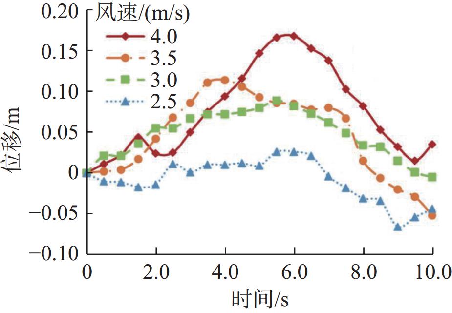
图 4 不同风速条件下无人机位移曲线
Figure 4. Displacement curves of UAV under different wind speed conditions
表 1 无人机和相机主要参数
Table 1 Main parameters of UAV and cameras
无人机 相机 参数 数值 参数 数值 外形尺寸 0.289 5 m×0.289 5 m×0.196 0 m 传感器 1英寸CMOS 最大飞行高度 500 m 有效像素 2 000万 最大可承受风速 10 m/s 焦距 8.8 mm 最大飞行时间 30 min 光圈 f/2.8-f/11 工作环境温度 0~40 ℃ 照片尺寸 5 472 px×3 078 px 悬停精度 垂直:±0.1 m(视觉定位正常);±0.5 m(GPS定位正常)
水平:±0.3 m(视觉定位正常);±1.5 m(GPS定位正常)快门 8~1/8 000 s  下载: 导出CSV
表 2 各摄距单位像素及视场大小对比
Table 2 The comparison of unit pixel and field size of each range
摄距/m 单位像素大小/mm 视场长/m 视场宽/m 3 0.82 4.48 2.52 4 1.09 5.97 3.36 5 1.36 7.46 4.20
下载: 导出CSV
表 3 图像测量实际宽度对比
Table 3 Image measurement actual width comparison
模拟裂缝宽度/mm 测量最大宽度/mm 测量最小宽度/mm 模拟裂缝宽度/mm 测量最大宽度/mm 测量最小宽度/mm 0.5 2.45 1.64 2.5 3.27 2.45 0.8 3.27 1.64 3.0 4.09 1.64 1.0 3.27 1.64 3.5 4.09 2.45 1.5 3.27 2.45 4.0 4.91 2.45 2.0 3.27 1.64
下载: 导出CSV
-
[1] 汪大全. 无人值守无人机在大坝边坡智能巡视检查中的应用[J]. 电子技术与软件工程,2022(7):131-134. (WANG Daquan. Application of unmanned aerial vehicles in intelligent inspection of dam slopes[J]. Electronic Technology & Software Engineering, 2022(7): 131-134. (in Chinese) WANG Daquan. Application of unmanned aerial vehicles in intelligent inspection of dam slopes[J]. Electronic Technology & Software Engineering, 2022(7): 131-134. (in Chinese)
[2] 顾诚. 无人机技术综述及其在水利行业的应用[J]. 江苏科技信息,2019,36(34):39-41 (GU Cheng. Summary of the technology of unmanned aerial vehicles and the application in the water conservancy industry[J]. Jiangsu Science & Technology Information, 2019, 36(34): 39-41. (in Chinese) GU Cheng. Summary of the technology of unmanned aerial vehicles and the application in the water conservancy industry[J]. Jiangsu Science & Technology Information, 2019, 36(34): 39-41. (in Chinese)
[3] 董月群, 冒建华, 梁丹, 等. 城市河道无人机高光谱水质监测与应用[J]. 环境科学与技术,2021,44(增刊1):289-296 (DONG Yuequn, MAO Jianhua, LIANG Dan, et al. Water quality monitoring and application in urban river based on hyperspectral of unmanned aerial vehicle[J]. Environmental Science & Technology, 2021, 44(Suppl1): 289-296. (in Chinese) DONG Yuequn, MAO Jianhua, LIANG Dan, et al. Water quality monitoring and application in urban river based on hyperspectral of unmanned aerial vehicle[J]. Environmental Science & Technology, 2021, 44(Suppl1): 289-296. (in Chinese)
[4] 张冬晓, 陈亚洲, 程二威, 等. 适用于无人机数据链电磁干扰自适应的环境监测系统[J]. 高电压技术,2020,46(6):2106-2113. (ZHANG Dongxiao, CHEN Yazhou, CHENG Erwei, et al. Environmental monitoring system suitable for electromagnetic interference adaptation of UAV’s datalink[J]. High Voltage Engineering, 2020, 46(6): 2106-2113. (in Chinese) ZHANG Dongxiao, CHEN Yazhou, CHENG Erwei, et al. Environmental monitoring system suitable for electromagnetic interference adaptation of UAV’s datalink[J]. High Voltage Engineering, 2020, 46(6): 2106-2113. (in Chinese)
[5] 张毅, 刘天立, 刘越, 等. 深度学习在输电线路无人机巡检中识别防振锤缺陷的应用[J]. 武汉大学学报(工学版),2022,55(10):1065-1071. (ZHANG Yi, LIU Tianli, LIU Yue, et al. Application of deep learning in vibration damper defect identification to UAV inspection of transmission line[J]. Engineering Journal of Wuhan University, 2022, 55(10): 1065-1071. (in Chinese) ZHANG Yi, LIU Tianli, LIU Yue, et al. Application of deep learning in vibration damper defect identification to UAV inspection of transmission line[J]. Engineering Journal of Wuhan University, 2022, 55(10): 1065-1071. (in Chinese)
[6] 李建峰, 段宇涵, 王仓继, 等. 无人机在输电线路巡检中的应用[J]. 电网与清洁能源,2017,33(8):62-65, 70. (LI Jianfeng, DUAN Yuhan, WANG Cangji, et al. Application of the unmanned aerial vehicle in the transmission line inspection[J]. Advances of Power System & Hydroelectric Engineering, 2017, 33(8): 62-65, 70. (in Chinese) LI Jianfeng, DUAN Yuhan, WANG Cangji, et al. Application of the unmanned aerial vehicle in the transmission line inspection[J]. Advances of Power System & Hydroelectric Engineering, 2017, 33(8): 62-65, 70. (in Chinese)
[7] 王琳琳, 李俊杰, 康飞, 等. 基于无人机图像拼接技术的大坝健康监测方法[J]. 人民长江,2021,52(12):236-240. (WANG Linlin, LI Junjie, KANG Fei, et al. Dam health monitoring method based on image mosaic technology of unmanned aearial vehicle[J]. Yangtze River, 2021, 52(12): 236-240. (in Chinese) WANG Linlin, LI Junjie, KANG Fei, et al. Dam health monitoring method based on image mosaic technology of unmanned aearial vehicle[J]. Yangtze River, 2021, 52(12): 236-240. (in Chinese)
[8] 陈荣敏, 王皓冉, 汪双, 等. 基于无人机的坝面裂纹缺陷智能检测方法[J]. 水利水电科技进展,2021,41(6):7-12. (CHEN Rongmin, WANG Haoran, WANG Shuang, et al. Intelligent detection method of crack defects on dam surface based on UAV[J]. Advances in Science and Technology of Water Resources, 2021, 41(6): 7-12. (in Chinese) CHEN Rongmin, WANG Haoran, WANG Shuang, et al. Intelligent detection method of crack defects on dam surface based on UAV[J]. Advances in Science and Technology of Water Resources, 2021, 41(6): 7-12. (in Chinese)
[9] 朱征, 包腾飞, 郑东健, 等. 基于无人机倾斜摄影的白格堰塞区三维重建[J]. 水利水电科技进展,2020,40(5):81-88. (ZHU Zheng, BAO Tengfei, ZHENG Dongjian, et al. 3D reconstruction of Baige landslide area based on UAV oblique photographs[J]. Advances in Science and Technology of Water Resources, 2020, 40(5): 81-88. (in Chinese) ZHU Zheng, BAO Tengfei, ZHENG Dongjian, et al. 3D reconstruction of Baige landslide area based on UAV oblique photographs[J]. Advances in Science and Technology of Water Resources, 2020, 40(5): 81-88. (in Chinese)
[10] 林小莉, 刘英, 张清凌, 等. 基于无人机航空摄影的尾矿库溃坝数值模拟[J]. 水利水电技术(中英文),2021,52(5):71-81. (LIN Xiaoli, LIU Ying, ZHANG Qingling, et al. UAV aerial photography-based numerical simulation on failure of tailings reservoir dam[J]. Water Resources and Hydropower Engineering, 2021, 52(5): 71-81. (in Chinese) LIN Xiaoli, LIU Ying, ZHANG Qingling, et al. UAV aerial photography-based numerical simulation on failure of tailings reservoir dam[J]. Water Resources and Hydropower Engineering, 2021, 52(5): 71-81. (in Chinese)
[11] 周仁练, 马佳佳, 苏怀智. 基于无人机载红外-可见双光成像的土石堤坝渗漏巡查方法[J]. 河海大学学报(自然科学版),2023,51(3):154-161. (ZHOU Renlian, MA Jiajia, SU Huaizhi. Leakage inspection method of earth-rock embankment based on UAV with infrared and visible dual-light imaging[J]. Journal of Hohai University (Natural Sciences), 2023, 51(3): 154-161. (in Chinese) ZHOU Renlian, MA Jiajia, SU Huaizhi. Leakage inspection method of earth-rock embankment based on UAV with infrared and visible dual-light imaging[J]. Journal of Hohai University (Natural Sciences), 2023, 51(3): 154-161. (in Chinese)
[12] 周仁练, 苏怀智, 刘明凯, 等. 基于被动红外热成像的土石堤坝渗漏探测试验研究[J]. 水利学报,2022,53(1):54-67. (ZHOU Renlian, SU Huaizhi, LIU Mingkai, et al. Experimental study on leakage detection of earth rockfill dams using passive infrared thermography[J]. Journal of Hydraulic Engineering, 2022, 53(1): 54-67. (in Chinese) ZHOU Renlian, SU Huaizhi, LIU Mingkai, et al. Experimental study on leakage detection of earth rockfill dams using passive infrared thermography[J]. Journal of Hydraulic Engineering, 2022, 53(1): 54-67. (in Chinese)
[13] 赵薛强, 凌峻. 无人机自动巡检智慧监控系统研究与应用[J]. 人民长江,2022,53(6):235-241. (ZHAO Xueqiang, LING Jun. Development and application of intelligent monitoring system with UAV automatic inspection[J]. Yangtze River, 2022, 53(6): 235-241. (in Chinese) ZHAO Xueqiang, LING Jun. Development and application of intelligent monitoring system with UAV automatic inspection[J]. Yangtze River, 2022, 53(6): 235-241. (in Chinese)
[14] 赵薛强. 一种无人机图像识别技术体系研究与应用[J]. 中国农村水利水电,2022(5):195-200. (ZHAO Xueqiang. The study and application of a UAV image recognition technology system[J]. China Rural Water and Hydropower, 2022(5): 195-200. (in Chinese) ZHAO Xueqiang. The study and application of a UAV image recognition technology system[J]. China Rural Water and Hydropower, 2022(5): 195-200. (in Chinese)
[15] 时梦楠, 崔博, 王佳俊, 等. 复杂施工条件下无人碾压机群协同全覆盖路径规划研究[J]. 水利学报,2020,51(12):1544-1557. (SHI Mengnan, CUI Bo, WANG Jiajun, et al. Research on cooperative complete coverage path planning for unmanned roller group under complex construction conditions[J]. Journal of Hydraulic Engineering, 2020, 51(12): 1544-1557. (in Chinese) SHI Mengnan, CUI Bo, WANG Jiajun, et al. Research on cooperative complete coverage path planning for unmanned roller group under complex construction conditions[J]. Journal of Hydraulic Engineering, 2020, 51(12): 1544-1557. (in Chinese)
[16] 王小刚, 赵薛强, 王建成. 贴近摄影测量在水利工程监测中的应用[J]. 人民长江,2021,52(增刊1):130- 133. (WANG Xiaogang, ZHAO Xueqiang, WANG Jiancheng. Application of close photogrammetry in water conservancy engineering monitoring[J]. Yangtze River, 2021, 52(Suppl1): 130-133. (in Chinese) WANG Xiaogang, ZHAO Xueqiang, WANG Jiancheng. Application of close photogrammetry in water conservancy engineering monitoring[J]. Yangtze River, 2021, 52(Suppl1): 130-133. (in Chinese)
[17] 徐昊, 彭雪村, 卢志芳. 基于四旋翼无人机的桥梁裂缝检测系统设计[J]. 水利水运工程学报,2018(1):102-110. (XU Hao, PENG Xuecun, LU Zhifang. Design of quadrotor-based bridge crack detection system[J]. Hydro-Science and Engineering, 2018(1): 102-110. (in Chinese) XU Hao, PENG Xuecun, LU Zhifang. Design of quadrotor-based bridge crack detection system[J]. Hydro-Science and Engineering, 2018(1): 102-110. (in Chinese)
[18] 赵克华, 郑朝晖, 李金宵, 等. 基于无人机正射影像的河道水域动态监测模型的研究: 以浙江省宁波市鄞州区为例[J]. 水利水电技术,2019,50(10):77-83. (ZHAO Kehua, ZHENG Zhaohui, LI Jinxiao, et al. Orthophoto image of unmanned aerial vehicle-based study on dynamic monitoring model of river water area: a case study of Yinzhou District of Ningbo City in Zhejiang Province[J]. Water Resources and Hydropower Engineering, 2019, 50(10): 77-83. (in Chinese) ZHAO Kehua, ZHENG Zhaohui, LI Jinxiao, et al. Orthophoto image of unmanned aerial vehicle-based study on dynamic monitoring model of river water area: a case study of Yinzhou District of Ningbo City in Zhejiang Province[J]. Water Resources and Hydropower Engineering, 2019, 50(10): 77-83. (in Chinese)
[19] 李欣庆, 袁秀忠, 魏星. 无人机倾斜摄影测量在河道凌情监测中的应用[J]. 人民黄河,2020,42(增刊1):159-161. (LI Xinqing, YUAN Xiuzhong, WEI Xing. The application of drone tilt photogrammetry in river ice monitoring[J]. Yellow River, 2020, 42(Suppl1): 159-161. (in Chinese) LI Xinqing, YUAN Xiuzhong, WEI Xing. The application of drone tilt photogrammetry in river ice monitoring[J]. Yellow River, 2020, 42(Suppl1): 159-161. (in Chinese)
[20] 张际泽, 刘礼. 无人机摄影测量在工程建设中的应用[J]. 四川水力发电,2020,39(4):69-73. (ZHANG Jize, LIU Li. Application of UAV photogrammetry in engineering construction[J]. Sichuan Water Power, 2020, 39(4): 69-73. (in Chinese) ZHANG Jize, LIU Li. Application of UAV photogrammetry in engineering construction[J]. Sichuan Water Power, 2020, 39(4): 69-73. (in Chinese)
[21] 梅智. 基于无人机图像的混凝土坝表观裂缝监测研究[D]. 大连: 大连理工大学, 2020. (MEI Zhi. Study on monitoring of apparent cracks in concrete dams based on UAV images[D]. Dalian: Dalian University of Technology, 2020. (in Chinese) MEI Zhi. Study on monitoring of apparent cracks in concrete dams based on UAV images[D]. Dalian: Dalian University of Technology, 2020. (in Chinese)
[22] 邓雅心, 骆旭佳, 李红林, 等. 基于无人机倾斜摄影测量技术的水电站坝面裂缝检测研究[J]. 科技创新与应用,2021(5):158-161, 166. (DENG Yaxin, LUO Xujia, LI Honglin, et al. Research on crack detection of dam surface of hydropower station based on UAV tilt photogrammetry technology[J]. Technology Innovation and Application, 2021(5): 158-161, 166. (in Chinese) DENG Yaxin, LUO Xujia, LI Honglin, et al. Research on crack detection of dam surface of hydropower station based on UAV tilt photogrammetry technology[J]. Technology Innovation and Application, 2021(5): 158-161, 166. (in Chinese)
计量
- 文章访问数: 0
- HTML全文浏览量: 0
- PDF下载量: 0
